Stage 3: Clecy to Bayeux (35 miles)
To get across to Bayeux, you can go back about 15 miles
along the river route, then 20 miles on small roads. The latter part
involves climbing out of the river valley onto the plateau, then some
undulating cycling thereafter - so quite hilly overall.
The reward is the beautiful town of Bayeux. Even without the tapestry
(which isnt viewable in Bayeux from Sept 2025 to October 2027 because
the site is being refurbished - but will be in the British Museum
in the later part of this period), there's plenty to see, including an
impressive cathedral and various museums, as well as being a lovely old
city to stroll round.
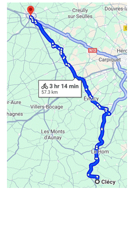
There are various ways of doing this route. I'm not convinced the way I
did it (via Aunay and Villers Bocage) is the best one, and I'm basing
my distances on the shorter Google Maps version (set it to
"cycle" mode), which is probably better, and you may want to try it -
please let me know if it works well. Sometimes in France, Google sends
cyclists down impractical bumpy paths, but from what I can see there
are few if any unpaved sections on this one.
If you decide instead to go via Aunay and Villers as I did (eg if one
of their markets is on, or if you dont want to risk being diverted onto
bumpy farm tracks), use mainly the D6 from Thury Harcourt to Villers
Bocage and D67 from the bottom of Villers all the way to Bayeux (very
pleasant), EXCEPT the D6 between Aunay and Villers is rather busy so
you can do a little detour from 1km after Aunay to Epinay on the D214
then D71 to Villers. Note that this route uses less of the cycleway to
start, and is about 4 miles longer overall: overall, it's about 8 miles
on the cycleway and 31 on roads .
Here is an overview of the Google version:
Back to start page